

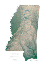
Between the winding Mississippi and Yazoo rivers lies a fertile delta, and east of the Yazoo are the Pearl, the Big Black, and the Pascagoula River drainages. The Mississippi map displays the sandy hills of the northeast which give way to pine woods, prairie, and finally the Gulf Coast.
All of our state wall maps display an incredible amount of detail, from cities, highways, and mountain ranges, to valleys, rivers, and small towns. Mississippi map elevations are represented by color, and this, in combination with our relief shading technique, gives the map a lush, 3-dimensional look.
Mississippi Map Dimensions: 32" x 48"
Mississippi Map Scale: 1:500,000 (1" = about 8 miles)
by Raven Maps